New Jersey Future Blog
Deadline Extended to May 31! Apply for a 2020 Smart Growth Award
January 13th, 2020 by Emily Eckart
![]()
Deadline extended to May 31!
Development shapes our landscapes, social lives, and environmental outcomes. New Jersey Future’s Smart Growth Awards celebrate projects that lead the way toward better development. We’re looking for innovators who go beyond buildings. We want projects that create places and solve problems. Past winners have included an indoor vertical farm that addressed an urban food desert, an abandoned factory converted into affordable housing, a bike trail that reduced car travel, and a sustainable urban co-working space.
If you know a project, plan, or initiative that contributes to a brighter future for New Jersey, submit it for consideration today! The application process is through an easy online submission portal. You should get started now on your application now – -it takes some time to collect all the required information to put your project’s best foot forward. Winners will be celebrated at an event at the Newark Museum on September 30, 2020.
Entries will be judged by an independent panel of experts in various aspects of growth and development. Applications are judged against the following considerations:
- Proximity to existing development or infrastructure
- Creation or enhancement of a vibrant mix of uses: residential, office, and retail
- Protection of open space, farmland, parks, and critical environmental areas
- Creation of a range of housing options (size, type, and affordability)
- Creation or enhancement of various transportation options
- Improved resilience against natural hazards
- Walkability and neighborhood interaction
- Integration into surrounding community
- Green design
- On-site stormwater management
Learn more about the application process and read about past winners on our website. We look forward to seeing this year’s entries!
Questions? Contact Michele Glassburg, (609) 393-0008, ext. 107.
Resilience planning in Medford
January 7th, 2020 by Tanya Rohrbach
 Climate change is here. It has already contributed to more severe flooding from increased precipitation and sea level rise, posing an immediate challenge to municipalities located in low-lying floodplains.
Medford, NJ is addressing the problem head-on. As part of New Jersey Future’s Community Rating System (CRS) planning assistance program, the town met with NJF’s planning team on Dec. 19 to begin the process of becoming a CRS community. The Medford Township Council deliberated and ultimately adopted a resolution to pursue the CRS project. NJF is providing the necessary strategic planning to assess and organize Medford’s application to the CRS program.
CRS is a program administered by the Federal Emergency Management Agency (FEMA). It is a voluntary incentive program that recognizes and encourages community floodplain management activities that reduce the risk of flood damage. Benefits of participating in CRS include discounted flood insurance rates, enhanced public safety and flood awareness, reduced property and infrastructure damage, better stormwater control, and increased recreation opportunities.
Would your community benefit from CRS participation? Learn how New Jersey Future can help.
Funding for the Community Rating System to Preserve Floodplains project was supported through the Open Space Institute’s Delaware River Watershed Protection Fund which is made possible with funding from the William Penn Foundation
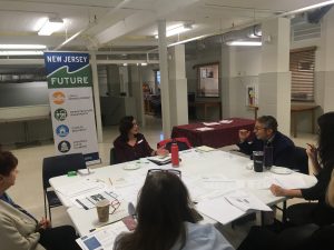
Planning for Aging-Friendliness in Fair Lawn Borough
December 17th, 2019 by Tanya Rohrbach
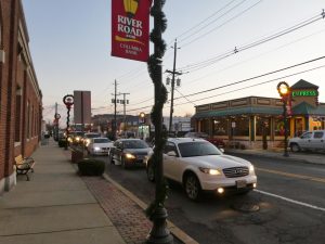
The River Road Improvement District is one of Fair Lawn’s downtown areas.
Fair Lawn Borough is working with New Jersey Future to make its community more aging-friendly. At a kickoff meeting on December 11, New Jersey Future described how local land use patterns and policies can affect whether residents can continue living and being active in their communities as they age.
Key components of aging-friendly communities include:
- Housing affordability and diversity
- Transportation
- Walkability
- Access to destinations and public spaces or facilities
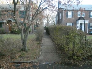
A pedestrian walkway between homes. Pedestrian paths contribute to walkability, which is one characteristic of an aging-friendly community.
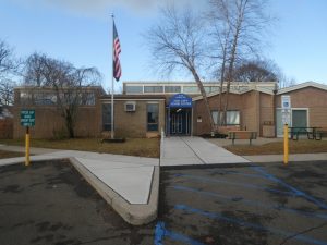
Fair Lawn Senior Center
Through a decision-maker and stakeholder engagement process, New Jersey Future will facilitate aging-friendly implementation planning in Fair Lawn over the next year.
Kudos to Fair Lawn for integrating aging-friendly community building into local planning!
Want to make your own community more aging-friendly?
You can find resources on New Jersey Future’s page about creating great places to age, as well as the North Jersey Alliance of Age-Friendly Communities blog.
Free event! Learn how CSO plans can address climate change
December 12th, 2019 by New Jersey Future staff
 Climate change is here. New Jersey municipalities are already struggling with sea level rise, more intense storms, and extreme heat. As 21 cities plan upgrades worth billions for their outdated combined sewer systems, are they taking these dangers into account?
Learn how municipalities can factor climate change in their combined sewer overflow (CSO) long term control plans at a free event on January 28. Join New Jersey Future, the Sewage-Free Streets and Rivers campaign, and the New Jersey Climate Change Alliance for a conversation with state and local leaders to learn how they’re planning to incorporate climate challenges into sewer system upgrades — and how those upgrades will affect your neighborhood. Most importantly, explore solutions everyone can work toward.
This event has been certified for the following continuing education credits:
American Institute of Certified Planners (2.0 certification maintenance credits)
NJ State Board of Professional Engineers & Land Surveyors (2.0 CPC credits)
Attendance is free, but registration is required. Sign up now to reserve your spot.
Tuesday, January 28, 2020,6:00 pm to 8:00 pm (light refreshments available)
Elizabeth Public Library (main branch)
11 South Broad Street, Elizabeth NJ
Questions? Contact Mo Kinberg at mkinberg@ njfuture.org
Speakers:
- J. Christian Bollwage, Mayor of Elizabeth
- Dave Rosenblatt, Chief Resilience Officer, The State of New Jersey
- Janice Brogle, Acting Director, Division of Water Quality, New Jersey Department of Environmental Protection
- Marjorie Kaplan, Dr.P.H., Associate Director, Rutgers Climate Institute, Rutgers University
- Andy Kricun, PE, BCEE, Executive Director/Chief Engineer, Camden County Municipal Utilities Authority
- Alan Cohn, Managing Director, Integrated Water Management, New York City Department of Environmental Protection
- Pete Kasabach, Executive Director, New Jersey Future
- Kim Gaddy, Environmental Justice Organizer, Clean Water Action
- Jackie Park Albaum, Director of Urban Agriculture, Groundwork Elizabeth
This event is hosted by New Jersey Future
.![]()
Event sponsors:
![]()
Event partners:

This event is neither sponsored nor endorsed by the Elizabeth Public Library.
Celebrating the 20th Anniversary of New Jersey’s Transit Village Program
December 9th, 2019 by Tim Evans

Representatives from each of the Transit Villages were honored at the celebration.
Happy 20th birthday to New Jersey’s Transit Village program! The NJ Department of Transportation and NJ Transit jointly hosted an event on November 14 to commemorate the 20th anniversary of the Transit Village program, which incentivizes municipalities hosting transit stations (commuter rail, light rail, or major bus terminal facilities) to promote transit-oriented development (TOD). TOD puts homes, jobs, shopping, and other important destinations within walking distance of public transit to create an environment where a car is optional, not necessary.
The program has grown from the original five Transit Villages – Morristown, Pleasantville, Rutherford, South Amboy, and South Orange – to include 34 transit-hosting municipalities in almost every corner of the state. The event looked back on how the program has helped Transit Village municipalities capitalize on their transportation assets, and also looked forward toward the challenges and opportunities facing transit-hosting towns in the future.

Speakers presenting at the event
Municipal officials from some of the Transit Villages cited the program’s value as a marketing tool with which to attract developers. The “Transit Village” imprimatur serves to assure developers that this is the kind of place they’ve read about, where Millennials can find the “live-work-play” environment that they’re looking for, and where empty-nester Baby Boomers are looking to downsize into smaller “in-town” housing options. And it also signals to developers that local officials recognize their town’s strength as a transit-focused community and are looking for partners to help them build on that strength.
Looking ahead, panelists talked about the need to explore “micro-mobility” options like bike share and electric scooters to cover the “first mile/last mile” trip between the transit station and the traveler’s origin point or final destination. (Everyone is a pedestrian once they step off the bus or train; micro-mobility modes help shorten travel times and distances for people who would otherwise have to walk or take a taxi.) They also discussed the issue of housing affordability, and how to take advantage of growing market demand for transit-oriented living by providing enough new housing to absorb new residents without creating upward pressure on home prices and rents that might displace long-time residents.
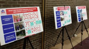
Some of the most pressing issues facing New Jersey’s Transit Villages are affordability and equity, public support, and connectivity.
Given that so much of the state’s recent population growth is taking place in transit-friendly places, New Jersey Future would like to see even more municipalities join the Transit Village program. Since “the great reset” around 2008, demand for living near transit has taken off. Prior to 2008, municipalities hosting transit stations were growing much more slowly than the rest of the state. Transit stations are mostly located in older towns and suburbs that were built before the automobile rose to be the dominant form of transportation. Many of these transit-hosting towns saw their populations stagnate or even decline when car-oriented suburbia became the default development paradigm, starting in the 1950s and lasting well into the first decade of the new century. But now, they find themselves on the receiving end of a new round of demand for in-town living. State agencies should provide whatever assistance and incentives they can to transit-hosting towns, to make sure these towns continue to be able to accommodate potential new residents who are looking to avail themselves of all the benefits TOD offers.
Apply for a 2020 Smart Growth Award
November 11th, 2019 by Emily Eckart
![]() Development shapes our landscapes, social lives, and environmental outcomes. New Jersey Future’s Smart Growth Awards celebrate projects that lead the way toward better development. We’re looking for innovators who go beyond buildings. We want projects that create places and solve problems. Past winners have included an indoor vertical farm that addressed an urban food desert, an abandoned factory converted into affordable housing, a bike trail that reduced car travel, and a sustainable urban co-working space.
Development shapes our landscapes, social lives, and environmental outcomes. New Jersey Future’s Smart Growth Awards celebrate projects that lead the way toward better development. We’re looking for innovators who go beyond buildings. We want projects that create places and solve problems. Past winners have included an indoor vertical farm that addressed an urban food desert, an abandoned factory converted into affordable housing, a bike trail that reduced car travel, and a sustainable urban co-working space.
If you know a project, plan, or initiative that contributes to a brighter future for New Jersey, submit it for consideration today! The application process is through an easy online submission portal. Winners will be celebrated at an event at the Newark Museum on September 30, 2020.
Entries will be judged by an independent panel of experts in various aspects of growth and development. Applications are judged against the following considerations:
- Proximity to existing development or infrastructure
- Creation or enhancement of a vibrant mix of uses: residential, office, and retail
- Protection of open space, farmland, parks, and critical environmental areas
- Creation of a range of housing options (size, type, and affordability)
- Creation or enhancement of various transportation options
- Improved resilience against natural hazards
- Walkability and neighborhood interaction
- Integration into surrounding community
- Green design
- On-site stormwater management
Learn more about the application process and read about past winners on our website. We look forward to seeing this year’s entries!
Questions? Contact Michele Glassburg, (609) 393-0008, ext. 107.
Where does impervious cover have the biggest impact?
November 11th, 2019 by Tim Evans
Impervious cover, surfaces such as roads and rooftops that are impenetrable to water, has economic and environmental impacts on municipalities. Streets and sidewalks are expensive to maintain and these surfaces generate stormwater runoff which causes flooding and carries polluted water into our streams and rivers.
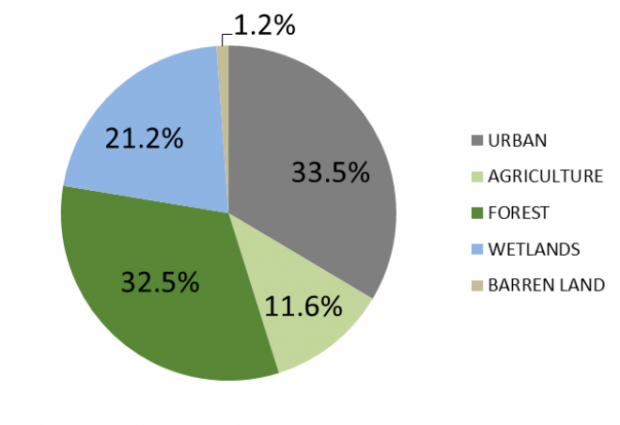
The New Jersey Department of Environmental Protection (DEP) recently released a 2015 update of its land use / land cover data set. The LU/LC dataset offers a periodic snapshot of how and where New Jersey both uses and preserves its land. For example, a little over one-third (33.5 percent) of the state’s land is urbanized and a little less than another third (32.5 percent) is forest, with another 11.6 percent in agricultural use and 21.2 percent in wetlands (and the small remainder classified as “barren land,” a catch-all category that includes things like beaches, quarries, and land that has been cleared for development but on which nothing has yet been built).
One feature of interest is the data set’s inclusion of an estimate of impervious surface – things like roads and rooftops that are impervious to water and hence generate stormwater runoff when it rains, rather than allowing water to soak into the ground. From the data provided for smaller plots of land, it is possible to produce summaries that show how much impervious surface in the state is due to which specific land-use categories. These summaries in turn illustrate an important, though perhaps counterintuitive, point about the environmental benefits of density.
Five of the 24 subcategories in the “urban” category of land use pertain to residential development of various types and are described as follows in the metadata:
- Residential (High Density or Multiple Dwelling): This category contains either high-density single units or multiple dwelling units on 1/8 to 1/5-acre lots. These areas are commonly found in the densely populated urban zones.
- Residential (Single Unit, Medium Density): This category is made up of residential urban/suburban neighborhoods greater than 1/8 acre and up to and including ½ acre lots.
- Residential (Single Unit, Low Density): This category contains single unit residential neighborhoods with areas greater than ½ acre up to and including 1 acre lots.
- Residential (Rural, Single Unit): This category contains single unit residential neighborhoods with lots that are at least one acre or larger. This type is typically found in sparsely populated regions surrounded by or adjacent to forested or agricultural lands. Also included are estates or modern sub-divisions with large lot sizes providing a density less than or equal to one dwelling unit per acre.
- Mixed Residential: The mixed residential category is used for an area where various residential uses occur and the individual uses cannot be separated at mapping scale (1 acre). Where more than 1/3 intermixture of other residential use or uses occurs in a specific area, it is classified as mixed residential. Where the inter-mixtures of other residential land use or uses total less than 1/3 of the specified area, the dominant land use category is applied.
By summing the total acreage and the impervious acreage for all pieces of land in the database within each of these five subcategories, we can construct estimates of the total amount of New Jersey’s land that is devoted to each of these uses, and what percent of each subcategory’s land is impervious surface:

Note that residential development overall devotes 38.8 percent of its acreage to impervious surfaces, on average. Residential development thus produces slightly less impervious surface per acre than urban land more generally, because other types of urban uses – especially commercial and industrial properties – tend to build out a much higher percent of their lots with buildings and pavement (especially parking lots) and don’t tend to have much in the way of green space. (A little more than 15 percent of the state’s land area is covered by impervious surfaces overall.)
Lawns and wooded areas account for the main difference in impervious surface percent between residential development on one hand and other urban uses on the other. But they also account for differences among the different subcategories of residential development. Note that among the residential subcategories, the type that generates the most impervious coverage per acre is the highest density category; properties in this category, which tend to be found in the more densely populated urban areas in the state where lawns are both smaller and less common, typically have about 70 percent of their area covered by impervious surfaces. Even medium-density suburban neighborhoods, with 2 to 8 housing units per acre, devote nearly half (46.8 percent) of their land to impervious surfaces. In contrast, residential development in rural areas that is dominated by single-family detached homes on large lots (1 acre or more) only devotes an average of 20 percent of its total land area to driveways, roofs, and other impervious surfaces. It may thus appear that the most environmentally-friendly residential form, from the standpoint of generating stormwater runoff, is low-density subdivisions with big lawns and/or lots of trees.
But per acre is the wrong denominator to use in measuring residential development’s effect on impervious surface. When we talk about the future growth of a state, what we are talking about is how many new people or households the state expects to gain over a given time period. States seek to attract new residents, not new urbanized acreage. The number of new acres a state must develop is a function of how many new people move in, not the other way around. But the number of newly developed acres is also a function of how we choose to accommodate new population growth. Will most of it be accommodated via large-lot, single-family development, or via higher-density neighborhoods with apartments, townhouses, and single-family homes on smaller lots? The types of housing that new residents move into can have widely varying effects on how much new impervious surface gets added per new resident.
To keep the math simple, let’s consider a time frame over which New Jersey expects to have to supply 100,000 additional housing units. As of the 2018 American Community Survey, the average household size – that is, the number of people per occupied housing unit – in New Jersey is 2.69 people. Using this average, 100,000 new housing units translates to roughly 269,000 new people. This is about equivalent to the amount of population growth that has occurred in New Jersey from 2004 to 2018, a 14-year time frame. We are thus roughly considering how many new acres of impervious surface we can expect to be generated by about 14 years’ worth of population growth under different residential development scenarios.
For each of the four residential land-use categories for which the description specifies a density range, let us pick a representative value for number of units per acre: 10 units per acre for the densest category (this is actually quite a conservative estimate; neighborhoods dominated by rowhouses and apartments will have many more units per acre than 10), 5 units per acre for the medium-density category (which spans from 2 to 8 units per acre), 1.5 units per acre for low-density (lot sizes of between ½ and 1 acre), and 0.5 units per acre for suburban estate developments and rural areas (this corresponds to 2-acre lots; average lot sizes can of course be much larger than this in such developments). The table below shows what each of these development densities translates to, in terms of number of newly developed acres and thence new acreage of impervious surface.

Using the average impervious surface coverage rates of the different residential development types, we can see that when measured on a per-capita or per-household basis, rural single-family development produces by far the largest number of new acres of impervious surface for a given population increase; an additional 100,000 households will create 40,000 additional impervious acres. The highest-density housing types, in contrast, result in the least amount of new impervious surface – less than 7,000 new impervious acres for the same increase of 100,000 households. The tendency of higher-density housing types to cover more of their land area with impervious surfaces is more than made up for by the fact that higher density housing consumes far less acreage per person.
If the goal of more environmentally conscious development is to minimize the increase in impervious surface coverage (and thence stormwater runoff) that will be created by a given increase in population size, then, the best way to achieve this is by accommodating as much of the population increase in high-density, rather than low-density, housing types. Similarly, the cost to maintain roads and sidewalks in dense cities is distributed among more people, making dense development a more economic alternative to sprawling communities.
Addressing urban challenges at the APA Policy and Advocacy Conference
November 11th, 2019 by Peter Kasabach
Each year the American Planning Association (APA) holds its national Policy and Advocacy Conference to “provide attendees with the opportunity to connect with planners and officials on important planning policy issues, advocate for stronger communities by speaking out on legislative issues that affect planning, and learn how to address planning policy issues at the federal, state, and local levels.”
At this year’s conference, held in Washington DC on September 25, I spoke on a panel with Jessie Grogan from the Lincoln Institute of Land Policy (Lincoln) and Ben Forman from the Massachusetts Institute for a New Commonwealth (MassINC). Our task was to discuss the role of state policy in helping to advance “Legacy Cities.” Lincoln characterizes legacy cities as “older industrial centers with populations of less than 200,000, located primarily in the Midwest and Northeast.”
My co-presenters made two very important points. Jessie identified the importance of having experienced statewide policy organizations in place to convene stakeholders and drive policy change. She spoke about a new Lincoln initiative that will focus on working with a few of these statewide policy groups from around the country.
Ben discussed Massachusetts’s Gateway Cities program, which targets midsize urban centers that anchor regional economies for comprehensive revitalization efforts. Ben stressed the need for being strategic and targeted with state policy campaigns and the importance of building a coalition of supporters behind specific objectives.
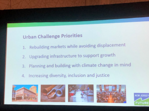
The panel discussed four urban challenge areas in the context of state policy:
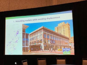
- Rebuilding markets. Most of the target cities are distressed. It is not possible to have a thriving and functioning city that is one hundred percent poor, therefore states need to subsidize and support reinvestment strategies that build markets and diversify the residential and commercial tax base. While gentrification and displacement are real issues, they are more common in wealthier cities and are not significant factors in rebuilding legacy cities.
- Upgrading infrastructure. These are old cities and most of the infrastructure, particularly water, is antiquated and dilapidated. This creates capacity, service disruption, and health issues, making it difficult for people and businesses currently in the city, as well as challenging to attract investors. State investment policies need to target urban infrastructure upgrades to create the foundation for growth and investment.
- Climate change. Many of our older cities were developed on bodies of water. These same waterways that were so attractive centuries ago now pose some of the biggest risks. States need to provide information, guidance, incentives, and disincentives to help cities steer investments in ways that don’t put people and property at current or future risk.
- Diversity, Inclusion, Justice. Legacy cities are often diverse, but they are also racially and economically segregated from their regions. For example, New Jersey is one of the most diverse states, but it is also one of the most segregated. Diversity in a global and innovation-based economy is an asset. States need to support and invest in policies that recognize diversity and immigration are competitive advantages.
2019 Complete Streets Summit
October 15th, 2019 by Kandyce Perry
 Every two years, the New Jersey Department of Transportation (NJDOT) and the Alan M. Voorhees Transportation Center at Rutgers hold the Complete Streets Summit to advance strategies to make our streets safer and more accessible to everyone.
A key theme of this year’s event was equity. Keynote speaker Ryan Russo, director of transportation at the Oakland Department of Transportation (OakDOT), described it this way: “When we talk about equity in transportation, it’s about reversing the decisions made by the predecessors of our profession, and being honest about some of those practices.” These practices included using eminent domain to take properties in black and brown neighborhoods for highway construction, concentrating poverty and segregating communities.
Focusing on underserved areas, OakDOT developed the Paint the Town program, which allows community members to paint temporary street murals reflecting the community’s cultures and values on Oakland’s roads. These projects engage community members to create something beautiful and meaningful, but they also provide something that might not be expected: safety. Road art is shown to slow traffic, making streets safer for pedestrians and cyclists. Efforts like the Paint the Town program are a strong model for creative ways to implement complete streets.
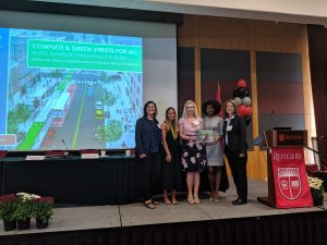
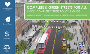 Equity was also a major focus of the morning plenary session, where panelists announced NJDOT’s new model complete and green streets policy and guide, a one-stop resource for New Jersey municipalities, counties, agencies, organizations, and advocates. It makes the connection between complete streets and health, economic development, green streets, and equitable transportation expenditures and project selection.
Kandyce Perry, planning and policy manager at New Jersey Future, explained during the plenary that the model policy and guide has sample language to implement benchmarks, which track where and what kind of street upgrades are prioritized: “This illuminates whether the communities of greatest need actually receive complete streets upgrades and provides the data to support just decision-making to achieve equitable transportation outcomes.”
Complete streets programs are successful when decision-makers and advocates can communicate with strong and plain language about the importance of transportation equity and safety, said Vinn White, senior transportation advisor to Governor Murphy. The model policy and guide provides that language. “The model policy was developed from a ground-up approach from a coalition of advocates in partnership with NJDOT” to increase the likelihood that these principles make it from policy to implementation, said Vinn.
Our streets are crucial networks that can make or break the health and vitality of our communities. Courtney Nelson of the American Heart Association closed out the plenary best: “The road to a healthier future is a healthy road.”
Local Implementation Planning in Ridgewood Village Will Help Create Great Places to Age in New Jersey
October 14th, 2019 by Tanya Rohrbach
 In light of an aging baby boomer population, towns across the country and state need to consider how to meet the needs of growing numbers of people over the age of 55. Aging-friendly communities are those that enable older adults to remain active, healthy, engaged, and capable of continuing to live in their communities. The built environment and land use patterns of a community are major determinants of livability factors like housing, mobility, and proximity to destinations and daily tasks. Because local decisions affect access to affordable or suitable housing, community services or employment, opportunities for social inclusion and physical activity, and transportation, New Jersey Future is engaging with municipal leaders and community members to implement community design for all ages in their towns.

As part of a two-phase program funded by The Henry & Marilyn Taub Foundation to create great places to age, New Jersey Future recently facilitated an implementation workshop in collaboration with aging-friendly coordinators from Westwood Borough, Teaneck Township, and Ridgewood Village. The leadership of Ridgewood Village has formed a steering committee to prioritize recommendations of the Aging-Friendly Land Use Analysis conducted by New Jersey Future. Going forward, the committee will work with New Jersey Future to develop an implementation plan. The workshop was the initial step in the implementation planning process and served to generate an enthusiastic discussion between Village stakeholders and decision-makers about what steps to take to ensure their community is a great place to grow up and grow old.